Monday, June 21, 2010

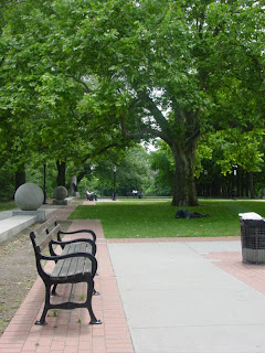
Central Park: Views into Tranquility

Central Park, southern end
Photographed June 19, 2010

Tranquil serendipity:  alluring yet intangible are these pockets of sanctuary that can only be experienced along their edges and beyond; inaccessible impressions of freedom and inhibition.  Nearby towers are no further than the blades of grass under the sunbather; their peering form is a direct reaction to the strata of the park's nestled havens.

Central Park: Pockets of Sanctuary

Central Park, southern end
Photographed June 19, 2010

While exploring urban paths and edges in order to understand how urban culture defines urban form I discovered the places of tranquility that join them.  I refer to them as pockets of sanctuary; places that adjoin paths which are not edges or nodes.  They are intimate places where individuals can solemnly recreate.  This photograph shows a place that is both intimate and grand, accommodating more than one experience of solitude at a time.

Central Park: Dichotomies in Behavior and Form

Central Park, southern end
Photographed June 19, 2010

An open yet compact, sunny yet shaded , anxious yet solemn vestibule of space attracts activities of multiple intensity.  Visitors can congregate in pairs, groups or exist in solitude; they can playfully run, walk, sit or lay.  


The terrain is inclined with varying widths of occupiable space, inviting only scattered pockets of activity; varying tree heights and sun angles encourage and discourage levels of social and environmental engagement and rocks leading to but not reaching the algae pond entice visitors to take the journey but ultimately deny them of completing it.

Central Park: Secluded Paths

Central Park, southern end
Photographed on June 19, 2010

This narrow and picturesque path outlined in bedrock and foliage is apprehensively inviting to the onlooker.  The setting creates an intimate oasis that offers challenged seating and obstructed views to heavier trodden paths.

Julliard School at Lincoln Center: Exclusive Form

The Julliard School
Photographed June 19, 2010

The robust Brutalist form of the Julliard School at Lincoln Center makes a linear connection to 65th street and the sidewalk.  The orthogonal symmetry is enhanced by angles that mimic highway ramps and structure.  Tree lined streets respond to Central Park located one block east.


The Julliard School
Photographed June 19, 2010

Brutalist architecture is not known to engage the pedestrian or encourage congregation.  This was fitting since project housing is located just one block to the west and built in tandem with Lincoln Center.  Recessed windows and walls offer security and privacy.  


Here exclusivity influenced form and design.

Lincoln Center for the Performing Arts: Nucleus of Activity

Lincoln Center
Photographed June 19, 2010

The buildings of the Lincoln Center for the Performing Arts form a u-shape around the ceremonial plaza.  Visitors and patrons who enter are brought up shallow steps that lead to a grand fountain in the plaza's center.  


65th St. is the path that extends between Alice Tully Hall and The Julliard School.  It terminates just before the Hudson River on the west and continues through Central Park on the east.  65th St. provides the linear anchor for the elevated park, shallow pool and social allee that exist between Alice Tully Hall and Avery Fisher Hall.  At just this one site Lincoln Center consumes three city blocks; outdoor social space encourages constant pedestrian traffic which is vital to maintaining safety since shows occur in the evening and indoors.

Returning to William Whyte's prescriptive list for successful urban social spaces:  opportunities for seating - visitors can choose to sit on the elevated park, in chairs provided under the allee of tree cover and along the edge of rectangular planters that help frame the tree allee; close proximity to the street - the promenade leading to the nucleus of activity abuts the sidewalk and street; sunlight - direct sunlight extends across the majority of the outdoor space though some sun angles are obstructed by relatively low building heights. sunlight is diffused by tree cover along the tree allee; opportunities for food - some white tents house food vendors; water feature - though not an interactive water feature, a long, orthogonal and shallow pool with a large sculpture at its eastern edge is present; trees and tree cover - a tree allee covers a gravel path, tables and seating; elements that encourage congregation - visitors choose to engage and congregate on the elevated park, around tables and chairs within the tree allee and at the tents of vendors.

This is a successful social space which reaches out to people of different economic backgrounds promoting safety and engagement.  The form of the social space reinforces function and social engagement.  The urban design in this instance was a reformation of the existing space in order to meet the needs of the owners and patrons of Lincoln Center.

Saturday, June 19, 2010

Lincoln Center for the Performing Arts

Lincoln Center
Photographed June 19, 2010

Unlike many urban renewal projects began by Robert Moses, the Lincoln Center for the Performing Arts was a heavily supported slum clearance project.  


Moses built many highways and public housing projects before beginning Lincoln Center.  Acres of tenement housing were cleared for the Lincoln Center complex and the project housing on its west side.  The Center offers parking and easy highway access to patrons arriving from outside of Manhattan.

Sunday, June 13, 2010

Watch the Fords Go By

Watch the Fords Go By
by A. M. Cassandre
Photographed June 12, 2010

"Watch the Fords Go By" was part of the "What was Good Design" exhibit at the Museum of Modern Art which focused on well designed everyday items from the mid 1940s to the mid 1950s.  


Leisure, automobiles and suburbs defined the middle class lifestyle during this time.  Highway construction allowed middle class families to leave the city for more space, recreation and safety while maintaining necessary access to the city for work and entertainment.

Paley Park: International Style

Photographed June 12, 2010

Developed by former CBS chairman William Paley, Paley Park is a pocket park located along the prominent path of E 53rd St. in Manhattan.  Just east and west, respectively, are The Seagram Building and the Museum of Modern Art (MOMA).

The architecture of both the Seagram Building and the MOMA are of the International Style and I contend that Paley Park is as well.  


The International Style was prevalent in America from the 1920s to the 1960s; Paley Park was completed in the 1967.  "Form follows function" is a common phrase that describes the International Style and like this style, the form of Paley Park follows its function.  The function of the park addresses each of William Whyte's characteristics of successful small urban social spaces:  seating - visitors can sit in the chairs provided or along the built in stone benches that span the majority of the park; close proximity to the street - the park is directly adjacent to the street; trees and tree cover - planters, ivy covered walls and tree cover; sunlight - diffused sunlight; water feature - a prominent waterfall; food - a built in kiosk selling cuisine; elements encouraging congregation - tables and chairs encourage congregation.  These functions form the space in a simplistic and linear manner.  Walls, seating, planters and trees are all along linear paths that are parallel to one another.  The waterfall in the rear and shallow steps balances the harmony of these lines with a perpendicular orientation. 

The International style was largely used for corporate buildings and Paley Park is largely used by corporate professionals.  In this way the culture has influenced form and therefore the design of the urban fabric.

Wednesday, June 9, 2010

Officer's Quarters, Brooklyn Navy Yard

Officer's Quarters
Brooklyn Navy Yard, southwest end
Photographed June 5, 2010

The City of New York and the federal government own the Brooklyn Navy Yard.  It is a historic industrial park currently being rehabilitated into a modern industrial park.  The Brooklyn Navy Yard Development Corporation is the not-for-profit organization that manages its redevelopment.

Recently, preservation and construction efforts were halted at the Officer's Quarters due to structural investigations that questioned preservation feasibility.


The Brooklyn Navy Yard is an industrial edge recessed inward from the Wallabout Bay and Channel.  It is responding to the transitioning population of the adjacent Fort Greene neighborhood by housing working class and middle class professions.

Fort Greene Park: Framed Views

Fort Greene Park, center
Photographed June 5, 2010

Fort Greene Park is hilly with winding and linear paths.  Its linear paths are framed with tree allees and emphasized with low walls meant for division, seating and framing.  The large sculptural finials add rhythm and break the otherwise picturesque path into smaller, more intimate and functional spaces.  The line of sunken gravel positioned between the wall and the brick pavement invites visitors to sit along the wall and look out at the large monument.  Park benches along the brick pavement accomplish the same activity.


Unfortunately not many visitors engaged this space, most chose to sunbathe on large swaths of inclined grassland with unobstructed sunlight, or gather in celebration on flat grassland with unobstructed sunlight.  A couple visitors chose a seat on a bench further along the path and a nondescript person chose to lie under the tree, but overall this space is not in heavy use.  

This space is an ideal outdoor classroom setting.  It is unappealing to recreational activity, thereby inspiring minimal distraction; it is at the peak of the park centered on a large monument, which is in tandem with academic instruction within classical and neoclassical architectural theory; and its inclusion of paved surfaces make the outdoor classroom more functional.  

As the Fort Greene neighborhood continues to make its transition to an upper middle class neighborhood this section of the park should see more use.  More school age children with more opportunities for traveling classrooms will alter the social fabric of the space.  As increased use unfolds the park should be able to include more lighting and re-design in order to increase its allure to its new visitors.

Cumberland St.

Cumberland St., Brooklyn NY
Photographed June 5, 2010

Cumberland Street is located in the Fort Greene neighborhood of Brooklyn, NY.  It is a residential path that extends from Atlantic Ave. to Dekalb Ave. at the southeastern edge of Fort Greene Park. Not all buildings are of the same architectural style or material but most are three story town homes in formidable condition.


The Fort Greene neighborhood used to be predominately African American, heavily employed by industrial jobs like those at the nearby Brooklyn Navy Yard.  When those jobs left the neighborhood it fell into a slumber; with increased violence, crime, gang and drug activity.  The neighborhood has since seen reinvestment and its racial composition is more diverse.

The current culture is catalyzing revitalization efforts; young families of European descent are buying homes as they are vacated by the elderly population and the building stock, though in need of maintenance is fitting for those who are looking to rehabilitate and retrofit historic homes.  Local businesses that cater to middle income residents are moving into the neighborhood and thriving.

Through its revitalization, Forte Greene is not returning to a working class neighborhood, instead it is steadily becoming an upper middle class neighborhood with homes selling for over $500,000.  As such the aesthetic of the hard scape is becoming more polished and picturesque.  Town homes are switching back to single family residences from mutli-tenant residences.  The tax base is increasing thus public spaces are more traversed with safer recreational and congregational traffic.

Tuesday, June 8, 2010

Village Alliance BID

Source:  Village Alliance   www.villagealliance.org

The Village Alliance Business Improvement District extends from Greenwich Village to East Village:  the main path is along 8th St. (east-west), secondary streets include 6th Ave. from 13th St. to 4th St. (north-south) and University Place from 13th St. to 8th St. (north-south).  


The paths are lined with retail, markets and restaurants; the 8th St. path connects the western portion of the Village Historic District with the eastern portion of the District:  8th St. is the only street within the BID that extends from 3rd Ave. to 6th Ave.  This long commercial connector services visitors, residents and students.  Minimal public bathrooms discourage some pedestrian visitors from remaining along the corridor for long periods which controls crowding.  

In this instance the social need for neighborhood connection and cohesion influenced the unification of the commercial corridor.  The purposeful omission of public bathrooms meant that the design of the space could continue to service a mostly local clientele, which keeps money and investment within the community.

The Highline: An Elevated Path

The Highline was once an elevated railway that has been rehabilitated into a park.  Its path begins in Chelsea and ends in the Gansevoort Market section of the Meatpacking District.  Its connection to the Chelsea art district is strong, as resident artists and art professionals were early Highline rehabilitation advocates.  Through commissions and partnerships the Highline is able to maintain its artistic connection.  www.thehighline.org

Autumn on the Hudson Valley with Branches, 2009 by Valerie Hegarty
Photographed May 29, 2010 north end of the High Line


The Highline is simultaneously an edge and a path.  The structure creates an edge along Chelsea's western edge, recessed inward from the Hudson River and dividing the piers and the waterfront from 10th Ave. east.  The park is an elevated path that connects Chelsea to the Meatpacking District via a tangible history, art and landscape.  This linear and elevated oasis of foliage also has a metaphysical path linking art to the visitor and the elevated rail culture of yore.  

In this way artistic sensibility shaped the landscape and design of the park; thus manifesting culture into design.

TASTES: Gansevoort Plaza Food Festival

On June 5, 2010 the Meatpacking District and Chelsea neighborhoods hosted TASTES 2010, a food festival and fundraiser for the middle and high NYC Lab SchoolsEach is a public school and funding goes to arts programs such as performance, culinary and fine art.  TASTES is an annual outdoor event that lines Gansevoort St. and Gansevoort Plaza with restaurateurs, pedestrians and entertainment.

Gansevoort Plaza, Meatpacking District, 2005
Source:  Gansevoort Plaza.  www.pps.org/gansevoortplaza


In 2005 criticism of the Gansevoort Plaza was that neighborhood revitalization was occurring more rapidly than safe pedestrian reclamation of the Plaza.  Transportation Planners were hired to resolve conflicting traffic patterns and a safer Plaza has attracted more events.

Gansevoort St. is a path that leads to the nodal Gansevoort Plaza.  Their activity is shaped by art and design exhibitions as well as dining.  Again, occupant use shaped updates to the urban form.  The re-design of the Plaza allowed a more functional pedestrian place.

The Meatpacking District: Cultural Influence on Form

Meatpacking District Initiative:  The Meatpacking District is located between Chelsea Market and Gansevoort St. at the northwestern edge of The Village Historic District.  In the late 1800s the neighborhood took shape as an outdoor market called Gansevoort Market on the site of Fort Gansevoort and in the mid 1900s it grew to Gansevoort Meat Center.  Meat processing shaped warehouse and road construction:  streets are wide, building are open, low and of masonry and steel construction.  

Artisans of diverse trades now occupy the meatpacking district and are responsible for its revitalization.  The local building form is ideal for the needs of artists and designers and their culture frames the Meatpacking District Initiative which promotes local business, attracts events and manages "the improvement of public space".  In this neighborhood the artisans established form and now drive their goals of urban design: historic and aesthetic interest, modern retrofitting, congregation and celebration.

14 St. Allee

CV Partnership in conjunction with the NY State Forestry Department ensured appropriate and maximized street plantings for 14th St.  www.cvpartnership.org

14th St is an east-west street located at the northern edge of the Village Historic District.  It marks the transition into the Village through architectural style, tree plantings, retail, residences and restaurants.  Sidewalks, historic mixed use buildings and tree cover provide the "generators of diversity" that Jane Jacobs writes about in the "Death and Life of Great American Cities" in order to maintain a critical mass of use and therefore safety.  

Strong pedestrian use and conservation of the thoroughfare ignited the need for tree plantings.  This is an additional layer to the environmental form and therefore an integral component of urban design.  The tree lined allee diffuses direct sunlight to pedestrians and frames the gestalt of the street for the driver.

Far West Village: Conserving Form and Style

Efforts to rezone the Far West Village are being considered by the Department of Planning after the Greenwich Village Society for Historic Preservation and community groups rallied for two years to restrict out of scale buildings and eliminate hotel and dorm incentives. www.gvshp.org

The Far West Village forms the western edge of the Village Historic District.  Residents are adamant about maintaining the architectural prestige of their neighborhood and therefore are driving the conservation of hard-scaped form and style.  As a result future design must oblige strict site based codes and ordinances in order to cohesively compliment neighborhood scale and design.

The Village: Nucleus of Activity

Village Historic District Map
Source:  The Greenwich Village Society for Historic Preservation.  www.gvshp.org

The Village Historic District is a node in lower Manhattan between the The Flatiron District and SOHO (South of Houston St.).  Kevin Lynch describes a node as being a nucleus of activity where paths and/or edges converge.

Wednesday, June 2, 2010

Jane Jacobs: Urban Activist

Jane Jacobs wrote "The Death and Life of Great American Cities" in 1961; her book challenged the urban planning principles of Robert Moses and his 20th century contemporaries.  She was against large scale urban renewal projects that displaced families through eminent domain and disengaged pedestrians via austere architectural form.  

"Death and Life ..." received both praise and criticism; critics pointed to her lack of historical, theoretical and practical understanding of urban planning while supporters focused on her public sensibility which countered planning practices at the time.  Though Jacobs did not have a formal planning education she inspired New Urbanists.  In her book she makes four recommendations for diversity:  multi-functional streets and districts; short blocks; multiple building use, function and type; and dense populations.

Robert Moses: Master Builder

Robert Moses led numerous urban renewal projects in New York City; erecting bridges, highways, parks, civic centers and large scale working class residential buildings; this made NYC a national model during the automobile age.  Moses' focus on the scale of the automobile rather than the scale of the pedestrian would ultimately aid in his downfall.  www.nytimes.com

As a political scientist he drafted legislation that created large public works authorities such as the Triborough Bridge and Tunnel authority.  These authorities were able to act independently; they gathered land under eminent domain and built regardless of strong public opposition.  Moses had little regard for preservation, city planning and architectural design.  Much of the housing he built lacked visual interest because he rejected the aesthetic and programmatic nuances that architects proposed.  Therefore, not only did his urban renewal projects obliterate the existing urban fabric and displace families, they also lacked high style architectural significance.  www.nytimes.com

Influential NYC Mayors since the 1898 Consolidation

NYC Mayors (Van Wyck - Giuliani)
Prior to the mid 1930s New York City's Mayoral accomplishments focused heavily on the development and construction of transportation systems.  Van Wyck brought the first subway contract to the City and Gaynor fought against efforts that inhibited the development of the subway system.  McClellon, Hylan and Walker spent a great deal of time working on transportation issues and saw the construction of several bridges, the West Side Highway and the Queens Midtown Tunnel.  Perhaps a unique accomplishment during the pre 1930s era was Mitchel's development of the nation's first Municipal Zoning Plan and New York City's "first comprehensive budget".  www.nyc.gov

After the mid 1930s the focus split, one part remained on transportation, the other shifted to the progress of social, urban and public welfare and the maintenance of capital.  LaGuardia's work with President Roosevelt's New Deal Administration led to funding for a unified "transportation network, ... parks, low income housing, bridges, schools and hospitals".  He also led the construction on what is now known as LaGuardia Airport.  O'Dwyer created the "Office of City Construction Coordinator" to which he appointed Robert Moses and Moses completed a number of highway and public housing projects during the tenure of Impellitteri.  Wagner directed the commencement and/or completion of several major thoroughfares, Shea Stadium and Lincoln Center for the Performing Arts and from 1964-1965 New York City was host to the World's Fair.  www.nyc.gov

Lindsay dealt with numerous transit strikes throughout his tenure.  He created the "Urban Action Taskforce and Neighborhood City Halls" in order to organize and address criticism and grievances placed against City services.  Lindsay also "consolidated City agencies ... and created community school districts". Beame combated municipal bankruptcy by reducing the capital budget, decreasing the municipal payroll and "secur[ing] annual federal loans"; Koch restored the capital budget.  Dinkins was New York City's first African American Mayor.  He heavily advocated for the eradication of the City's pension stock "invested in companies that [conduct] business in South Africa".  He also helped to pass a bill that ranked banks according to "their opposition to apartheid".  www.nyc.gov

Giuliani dramatically reduced the murder and overall crime rate in NYC making it "the safest large city in America".  He also decreased tax burdens that resulted in increased tourism and job creation.  Giuliani reduced municipal spending and the payroll without layoffs and established a reserve fund.  He implemented welfare reform via a workfare program and brought higher levels of accountability and performance standards to the school system. Current Mayor, Michael Bloomberg, reduced crime, increased job growth, supported rehabilitation of the City's parks and harbors, enacted public health strategies, increased high school graduation and literacy rates, increased "support for community arts organizations" and saw unemployment rates reach record lows.  He also generated and is implementing the "Five Borough Economic Opportunity Plan", a strategy focused on financial stability amid the recent financial downturn.  www.nyc.gov